The City of Venice (capital of the Veneto Region) is located in the North-eastern Italy. Founded in the 5° century (in the year 421) and spread over 118 small islands, Venice was inscribed in the UNESCO World Heritage List in 1987, in recognition of its unique historical, archaeological, urban and artistic heritage and exceptional cultural traditions, integrated into an extraordinary natural landscape. It covers a surface of about 540 square miles. According to the data referring to 2018, the City of Venice has a population of 261.321 inhabitants, distributed as follows:
- 53.799 inhabitants of the historic centre
- 27.983 inhabitants of the Lagoon’s islands
- 179.539 inhabitants in the mainland
Venice was built in an area where it was hard to find building materials; therefore, only two types of materials were available: the “spolia” (recycled) and the new materials. In the lagoon, between the end of the ancient world and the Middle Age, all the building materials were “spolia”/reused materials: foundation stones, decorated marbles, inscribed slabs, bricks, roof shingles, rubble. In fact, in ancient times, “spolia” materials were “bargaining chips” and their exchanges were governed by clear regulations. New materials arrived in the city only when Venice became an economic and military power. Both new and reused materials had to adapt to a climatic situation that was different from their places of origin, in particular to the high level of saltiness in the ground, in the water and in the air, that risks to break apart their structure. To guarantee that these CH materials could still last long there is a need for an efficient methodology to protect them from aggressive chemical and physical agents and possible hazards.


General description of the historic area section considered for the demonstration activities
The proposed sites have been identified for their different location in the urbis form of the city in order to understand how the main building materials (stone and marble, brick, wood, metal, plaster) can be quantitatively and qualitatively subject to chemical variations and exogenous physicists.
The selected focus areas are: 1) the Marciana area, 2) Ca’ Pesaro Palace. All of them are exposed to different pollutants from various sources. St. Mark square is mostly affected by the emissions of small boats and touristic large ships and Ca’ Pesaro is mainly exposed to the intense traffic along the Canal Grande. The CH building in the Marciana area, Torre dell’Orologio (The Clock Tower) has been selected for the demonstration activities and it can be classified in Tier 1 as sensors can be installed on it. Currently there are none.
Infrastructures and buildings to be classified in Tier 2: the bridge connecting Venice historical centre to the mainland allowing both car and train transportation, the buildings along the Grand Canal, from piazzale Roma to the Accademia bridge, the Rialto bridge and the Mercerie, the Giudecca canal, the Civil Hospital; these buildings and infrastructures are fundamental for the city and Business Continuity;
The area to be classified in Tier 3 includes the areas with infrastructures and important sites that border the lagoon and therefore the city of Venice, like the airport, the port mouths, the industrial site of Porto Marghera.
The dangers that can derive from these areas can have a serious impact on the city: if on the one hand the closure of the airport or of the port mouth can paralyse long-range transports, an accident occurring in in the petrochemical industry area might cause a block to the city life for a very long time.
With regard to the buildings and infrastructures included in levels T1 and T2, a further problem arises from the fact that all buildings and artifacts are of high historical and artistic value and the materials with which they are made have suffered great stresses since their first use, which is it aggravates daily with the highest level of pollution and with the increasing variability and intensity of climate change in recent years. An example for all is the increase in high tide levels over the last fifty years.
In consideration of climate change challenge (in the latest days the tide level raised at rates that are unprecedented), specific analysis of the effects of climate agents on building materials, and consequently on the techniques for their use, would help to understand which solutions are to be preferred for the restoration of the monuments and the buildings.
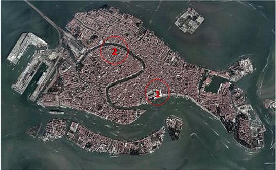
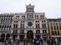 * The Marciana area, Torre dell’ Orologio (The Clock Tower)
The Clock Tower, is one of the most famous architectural landmarks in Venice, standing over an arch that leads from St. Mark’s square into what is the main shopping street of the city, the old Merceria. The tower with its large Astronomical Clock was designed by Mauro Colussi in the early 16th century, it was built with brick, stone and wood and covered with stone material. The monument that stands in the Marciana area, faces the city’s waterfront and it is therefore exposed to the sun, rain, high water, wind with all the saline humidity coming from the sea. In addition, the foundation of St. Mark square is lower than the rest of the city, and frequently subjected to the high water phenomenon, which comes directly from the large San Marco basin by wave motion. The presence of erosive salty water is massive, almost constant, and salt affects the buildings’ masonry. Its position makes it a perfect place where to position specific sensors to detect the polluting agents responsible for the deterioration of the building materials. Therefore, the building can be classified in Tier 1.
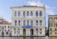 * Ca’ Pesaro Palace
The grand palace of Ca ’Pesaro, now seat of the International Gallery of Modern Art, was built in the second half of the seventeenth century after a project by the Venetian baroque architect, Baldassarre Longhena.
Overlooking the Grand Canal, the city’s main waterway, very busy with motor boats, the Palace was built using the traditional techniques and materials of the time and the two facades were coated with the Istrian stone. The building is exposed to the intense traffic of public and private transport and the pollution is acute. The building is to be classified in Tier 2 as it might be difficult to obtain an authorisation for installing any sensor.
Current equipment/infrastructure available
- The City of Venice instituted a “Centro Previsioni e Segnalazioni Maree”- ICPSM (Tidal forecasting and early warning center). It has a dedicated service for the tide monitoring to constantly provide tide levels and weather conditions forecasts and manage the early warning systems. ICPSM has been collecting data on tide levels for the last 40 years. The ICPSM provides both near-real-time and historic meteorological data: sea level rises, air temperature, atmospheric pressure, relative humidity and precipitation, solar radiation and wind. The data are available also as spreadsheet on line at the following link: https://www.comune.venezia.it/it/content/dati-e-statistiche-0.
- The City operates a IT system (ARGOS) for the water traffic monitoring caused by the passage of large ships and private/commercial boats in the lagoon and especially in the San Marco basin and the Grand Canal, which cause the increase of the hydrocarbon level and a strong wave motion, with the consequent erosion of the banks. Moreover, given the proximity of the industrial pole of Porto-Marghera and the international Marco Polo airport, the quality of the air and the presence of heavy metals transported by wind and rain, which affect both superficially and in depth the stone materials and the bricks, with the consequent deterioration of the components, are constantly controlled
- The City developed a security monitoring system an integrated system for controlling and managing mobility, land and road safety in the territory of the Municipality of Venice. The Smart Control Room (SCR) collects and manages the information received through the various local public transport networks (water, buses, flights, trams, etc …), the video surveillance systems (CCTV) and the telecommunication networks. A camera is also installed on the Clock Tower, one of the two tier 1 selected CH building.
- Stations used for meteorological observations are located in the and on St. Mark’s basin – Tidal Centre HQ, located in Palazzo Cavalli, records air temperature, atmospheric pressure, relative humidity and precipitation – in San Giorgio station, located on homonymous island, records solar radiation and wind – in Punta Salute station, in St. Mark’s basin, records water temperature Charts about precipitation and wind,
- IWS The Common Data Sharing Web GiS Tool (Integrated Web System – IWS) is an on line tool collecting observation datasets and forecasts from the existing operational forecast systems in the Ionian Adriatic basin. It has just developed within the European project Interreg Adrion I-STORMS. It is managed by the City of Venice and the CNR – ISMAR. Data can be downloaded from seastorms.eu
The combined analysis of the data obtained by these control systems provide information to monitor the deterioration of the city and of its lagoon area. Regarding the buildings in the identified areas, they have been measured and registered in a free municipal database. Some sensors and devices have been installed to monitor their structural condition.
